
In the Information Technology and GIS Sector, the Company provides a broad range of services. With a staff strength of 35 and an ambitious expansion plan, NESPAK expects to register a strong growth in this Sector. So far, 49 projects have been undertaken by NESPAK in this Sector (36 in IT and 14 in GIS), in addition to providing specialized services on many projects in other sectors.
Identification of the type of satellite imagery required, acquisition, registration, enhancement, interpretation, classification and satellite image map production.
Digitization of maps using vector GIS and Computer Aided Design (CAD) systems, scanning, raster-vector-raster conversion, map joining and attribute attachment.
Digital Terrain Model (DTM) development using GPS survey, stereo satellite imagery, contour digitization and interpolation.
Spot elevations, river cross sections, canal and road alignments.
Development of GIS databases consisting of thematic map layers e.g., land use, soils, elevation, geology, slope, roads, watersheds, floodplain map layers and their integration with hydrologic, groundwater, evapotranspiration, watershed and river flow models.
Least cost solutions, suitability maps.
Map production at all scales and sizes.
NESPAK has a team of great IT professionals with vast exposure in different fields of Information Technology. All the professionals have immense experience of working with public sector organizations both for the preparation of Software Requirement Specifications (SRS) Documents and Complete Software Development.
The unique characteristic of IT professionals of NESPAK is the enormous experience in diversified fields and hands on experience in various IT related Projects. This is the reason that NESPAK has always relied on in house development of software for itself and is thus perhaps the only organization with all these qualities.
The IT professionals of NESPAK have a unique blend of experience and innovation. It has specialized professionals of Networking, Communications, Software Development, System Analysis and Design, Business Process Reengineering, Enterprise Resource Planning (ERP) Solutions, Web based applications, Databases, Software Configuration Managers, Software Architecture, and Technical Writing etc. IT Professionals have been involved in Software Development of 15 Relevant Projects as well engaged in the SRS Development of 25 Relevant Projects of the Government and Public Sector organizations.
The IT Professionals of NESPAK have the experience of working on VAX machines, VMS Operating Systems, AS 400, Oracle, SQL Server, Windows 2000, UNIX, Visual Basic, Visual C++, Java, Dot Net, Dreamweaver, Flash, Cisco routers and switches and on all the major IT technologies in the world.
With the growth of GIS technology world over, NESPAK's portfolio of GIS projects is also registering a steady growth, both at home and abroad. Utilities mapping, irrigation, urban planning, watershed management and dam engineering were the principal areas in which NESPAK secured and implemented GIS projects.
NESPAK secured its first project in the utilities sector when it provided complete GIS services for Sanitary Drainage Master Plan for Jeddah City. The entire existing sanitary network was digitized from existing drawings and overlaid on high-resolution satellite imagery. Relevant attribute data was attached with each pipe segment for a total of 1800 segments. Data for 24,000 manholes was entered. Proposed sanitary network was also shown.
Four GIS application projects have been executed in water resources sector. GIS services were provided for the Irrigation Improvement Project, Iran in which complete GIS database was developed for the existing irrigation network. Under the Flood Protection Sector Project, the development of Indus Flood Forecasting involved GIS flood plain maps for the entire Indus Basin. Besides, successful completion of Kaha Watershed Management Project led to the award of a World Bank-funded project for preparation of GIS based Drought Mitigation and Preparedness Plan for the drought affected area of Balochistan.
Under the new devolution plan in Pakistan, a Union Council is the primary unit of the Government. As a test case, GIS database is being developed for the Rewat Union Council in Murree for integrating data of various sectors on one platform. For this purpose, one meter resolution satellite image has been obtained from USA, which will be used as a base map for developing the entire database. This database will tremendously help the district officials in planning future development projects.
In the feasibility study for proposed Basha Diamer Dam Project, GIS is being extensively used for preparation of topographic maps, 3D models, geological mapping, power transmission line siting, etc.
Cost : Rs. 460 million
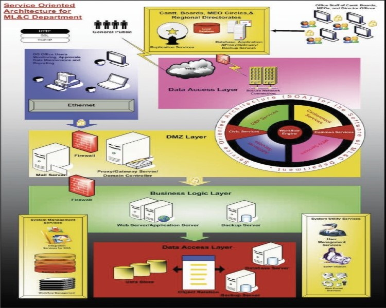
Client : Military Land and Cantonments Department
Cost : Rs. 8 billion
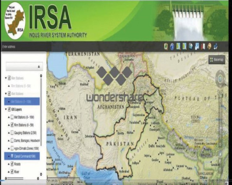
Client : Indus River System Authority, Islamabad
Cost : Rs. 18 billion
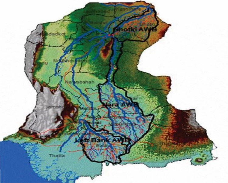
Client : (PMU) Government of Sindh

Cost : Rs. 7 billion
Client : Mazandran Colestan Regional Water Company

Cost : Rs. 404 billion
Client : Water and Power Development Authority
Cost : Rs. -.- billion
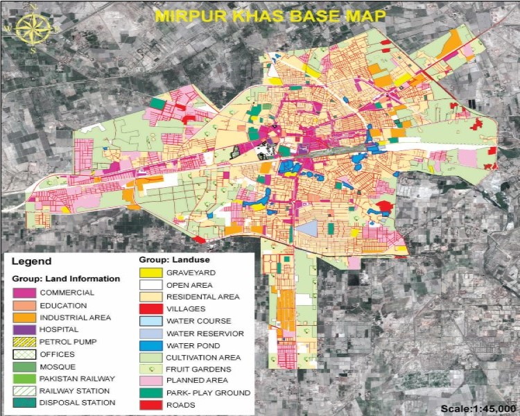
Client : Planning and Development Deptt. Government of Sindh


